EST. 1976 · INTERNATIONAL NAVIGATION SCHOOL (250) 702-3014 info@learntonavigate.com
COURSE 01 · CELESTIAL

Celestial Navigation Courses

Position fixing, passagemaking, sextant and compass use, and exam preparation — for non-professional and professional mariners.

Celestial sphere — latitude and longitude

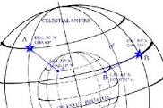
Navigation by fixing your position using angles between celestial bodies and the horizon has been around for thousands of years. Even in the age of satellite-powered GPS, computer navigation systems, and advanced radio-location, determining latitude and longitude positions teaches important fundamentals of navigation, provides a back-up navigation system in emergencies, and remains a fascinating hobby.

Our navigation courses break down the learning process into manageable blocks that build on one another to cover all aspects of celestial navigation and, in the case of professional mariners, prepare them for the relevant exams.

We offer two levels of Celestial Navigation courses

  • For sail and power association members, Canadian Yachting Association (CYA), or independent mariners: Celestial 1 completely equips you for all types of offshore voyages.
  • For candidates for Transport Canada, Marine Safety Certification: The second category involves Celestial 1 (Astro) and Celestial 2 (Astro Level 2). Celestial 2 consists of the advanced areas of Astro Navigation including The Sailings, required under the Marine Safety examination regulations. Astro Level 1 is available for Fishing Master certification preparation. The sight calculation device for this category is the Electronic Calculator. Marine Safety accepts the HO 229 tables.

Prior to registration we can discuss the choice of courses and methods and give you any advice you may need. The three methods of working sights are H.O. 229, H.O. 249, and the Electronic Calculator (Casio fx-991ms) — explained below.

Unit-by-unit, the content of Celestial 1 is as follows. (The units for Celestial 2 expand on these and include The Sailings.)

Course Units — Celestial 1

Unit 1

The Earth / The Celestial Sphere

  • How to identify our position and that of a celestial body relative to the equator and the Greenwich meridian.
Unit 2

The Navigation Triangle

  • How the position of a celestial body in the heavens can be established with reference to the observer's horizon and meridian.
Unit 3

Time

  • How to calculate the time at any location in the world.
  • The use of time in locating a celestial body with reference to our own position.
  • Using the Nautical Almanac in time calculations.
Unit 4

The Sextant

  • How a sextant is used to measure the altitude of a celestial body above the horizon.
  • Sight-taking techniques in various weather conditions.
  • Taking sights in your own backyard for practice and establishing the position of your house or apartment.
Unit 5

Latitude by Meridian Altitude

  • How we obtain our latitude (distance north or south of the equator) each day by using a heavenly body's altitude as it passes due north or south of the boat.
Unit 6

Latitude by Pole Star

  • How our latitude may be found twice daily using the Pole Star.
  • How to set the sextant at the altitude (angle) so that the star can be quickly found.
  • Using the compass to obtain direction.
Unit 7

The Astronomical Position Line

  • How, by locating the heavenly body's position on the celestial sphere and projecting it to earth, we can use it to obtain a line of position (LOP), indicating that we are located somewhere on that line.
Unit 8

Position Lines Using the Sun

  • By HO 229, HO 249, and Electronic Calculator methods.
  • Using pre-computed sight reduction tables or electronic calculator to find the intercept and azimuth of the sun and plotting the position line.
  • Steps are laid out in a clear and concise method.
Unit 9

Position Lines Using the Stars and Planets

  • By HO 229, HO 249, and Electronic Calculator methods.
  • Using pre-computed sight reduction tables or electronic calculator to find the intercept and azimuth of stars and planets and plotting the position line.
  • Steps are laid out in a clear and concise method.
Unit 10

Finding the Observed Position by Plotting Position Lines from Simultaneous Star and Planet Observations

  • By HO 229, HO 249, and Electronic Calculator methods.
  • After calculating intercepts and azimuths of stars and planets, how to plot the lines of position to achieve the observed position (fix).
Unit 11

Finding the Times of Sunrise, Sunset and Twilight using the Nautical Almanac

  • How to find the times of sunrise and sunset whether on shore or at sea.
  • How to find the times of evening or morning twilight so that the best observations of stars and planets can be made to obtain a fix.
Unit 12

Identifying Celestial Bodies using the Star Identifier and Nautical Almanac

  • Using the star identifier and nautical almanac to obtain the azimuth and altitude of stars and planets that are suitable for obtaining our position.
  • Using the star identifier to obtain a star or planet's name after a quick sight has been taken in cloudy weather.
Unit 13

Preparations for Taking Sights at Twilight and Daytime

  • Prior to twilight, choosing stars and planets that will give the best observed position when plotted on the chart.
  • Choosing the best time to take a sun observation for run up to the latitude obtained at the noon observation.
  • Calculating the time the sun will be on the meridian for observation for latitude.
Unit 14

Determining the Error of the Magnetic Compass

  • Observing stars, planets, sun and moon to determine compass error using HO 229, HO 249, or Electronic Calculator, ensuring an accurate course to your destination is being steered.
  • Selecting an instrument for taking accurate bearings of stars, planets, sun and moon.
Unit 15

A Day at Sea (on paper)

  • Taking morning, forenoon, noon, afternoon and evening sights for observed position.
  • Plotting position lines to obtain our observed position. This unit is excellent preparation for Sailing and Power Association examinations.

The Three Methods of Working Sights

1. HO 229

A very accurate method, produced in a six-volume series. This course uses Volume 3 (excerpts are included with the course materials). The tables are used with the Nautical Almanac to obtain elements necessary to determine position at sea. It is a straightforward method and requires no mathematical calculation beyond addition and subtraction of degrees, minutes, and decimals of minutes. A popular method.

2. HO 249

This method is actually for air navigation and, although slightly less accurate than HO 229, it is popular at sea because it is quicker and consists of only three volumes, so it takes up less space on board (excerpts are included in the course materials). As with HO 229, it is straightforward and requires no mathematical calculation beyond addition and subtraction of degrees, minutes, and decimals of minutes. Another popular method.

3. Electronic Calculator (Casio fx-991ms)

The fastest method, and as accurate as HO 229. It uses only three spherical trigonometric formulas — in fact two of them are the same ones used for the pre-computed tables HO 229 and HO 249. Once the operational use of the calculator is learned, the formulae are easily applied by following the keying sequences given with directions for solution (the Casio fx-991ms is the school calculator). A popular method — however, it is wise to carry spare batteries or an extra calculator in case of power failure or loss of instrument, and to have a backup method such as HO 229 or HO 249.

Register for this course